How Long Is the River Nile in Africa? The Definitive Guide to Its Massive Span
If you’ve ever wondered how long is the River Nile in Africa, you’re not alone. Stretching across multiple countries and shaping civilizations for thousands of years, the Nile is more than just a river—it’s a lifeline. Known for its historical, cultural, and geographical significance, the River Nile continues to fascinate travelers, students, and researchers who want to understand its true length and global importance.
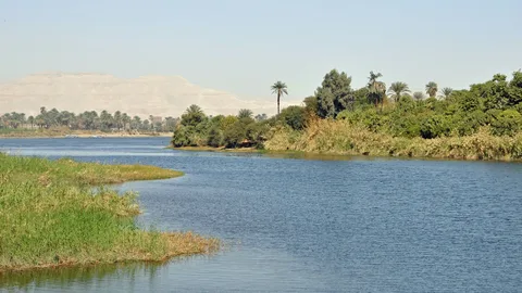
the river nile
The River Nile is one of the most famous rivers in the world and a defining feature of Africa’s geography and history. Flowing northward through northeastern Africa, it passes through or borders several countries, including Uganda, South Sudan, Sudan, and Egypt, before emptying into the Mediterranean Sea.
What makes the Nile especially remarkable is its role in supporting life. For thousands of years, communities have depended on it for fresh water, agriculture, transportation, and trade. Ancient Egyptian civilization, in particular, flourished along its banks, earning the Nile the nickname “the cradle of civilization.”
Today, the River Nile remains vital for millions of people and continues to spark global interest—especially when discussing how long is the River Nile in Africa and whether it is the longest river in the world.
How long is the river nile in africa?
The River Nile is approximately 6,650 kilometers (4,130 miles) long, making it the longest river in Africa and one of the longest rivers in the world. It flows northward from its farthest sources in East Africa to the Mediterranean Sea in Egypt.
When people ask how long is the River Nile in Africa, the answer reflects its incredible journey across 11 countries, including Uganda, South Sudan, Sudan, and Egypt. Its length has been measured and debated for years, but 6,650 km is the most widely accepted figure by geographers today.
This extraordinary length is one of the reasons the Nile has had such a powerful influence on African history, ecosystems, and human settlement.
Read:
Physiography of Nile River
The physiography of the Nile River refers to the physical features, landforms, and natural structure of the river along its long course across Africa. Because the Nile travels thousands of kilometers, its physiography changes significantly from its source regions to its mouth.
Source Regions and Highlands
The Nile originates from two main tributaries:
-
The White Nile, which begins near Lake Victoria in East Africa, flowing through low plateaus, lakes, and vast swamps such as the Sudd in South Sudan.
-
The Blue Nile, which rises in the Ethiopian Highlands, a region marked by steep slopes, volcanic plateaus, and deep river gorges.
Middle Course: Plains and Cataracts
As the Nile flows northward into Sudan, it passes through wide plains and semi-arid landscapes. In this section, the river forms several cataracts, which are rocky stretches and rapids created by hard rock formations. These features historically affected navigation and settlement patterns along the river.
Lower Course: Desert Valley and Delta
In Egypt, the Nile flows through a narrow, fertile valley surrounded by desert plateaus. This stretch contrasts sharply with the surrounding Sahara Desert. Near the Mediterranean Sea, the river fans out to form the Nile Delta, a broad, flat area made up of fertile alluvial soil deposited over thousands of years.
Overall Physiographic Significance
The diverse physiography of the Nile River explains its agricultural productivity, ecological variety, and long-standing human importance. From highlands and swamps to deserts and deltas, the river’s physical features have played a major role in shaping life along its banks.
Where is the source of the Nile river?
The source of the Nile River is traditionally traced to Lake Victoria in East Africa, making it the most widely accepted origin of the river. Lake Victoria is shared by Uganda, Kenya, and Tanzania, and it feeds the White Nile, the Nile’s longest tributary.
However, the Nile actually has two main sources:
White Nile Source
The White Nile begins at Lake Victoria and flows north through Uganda, South Sudan, and Sudan. Because it provides a steady year-round flow, it is considered the primary source of the Nile River.
Blue Nile Source
The Blue Nile rises from Lake Tana in the Ethiopian Highlands. Although shorter than the White Nile, it contributes most of the Nile’s water and fertile silt, especially during the rainy season.
Together, these two sources merge in Khartoum, Sudan, forming the main Nile River that continues north to Egypt and the Mediterranean Sea.
Also read:
The Nile’s hydrological regime
The Nile’s hydrological regime refers to the seasonal patterns of water flow, flooding, and discharge that define how the river behaves throughout the year. Unlike many major rivers, the Nile flows through regions with very different climates, which strongly influence its water regime.
Seasonal Flow Patterns
The Nile has a distinct seasonal flow, largely controlled by rainfall in the Ethiopian Highlands. During the summer months (June to September), heavy monsoon rains feed the Blue Nile, causing a significant rise in water levels downstream. This period historically resulted in annual flooding in Egypt and Sudan.
Role of the Blue Nile
The Blue Nile is the main driver of the Nile’s hydrological variability. Although shorter than the White Nile, it supplies the majority of the river’s water and nearly all of its sediment during the rainy season. These seasonal floods once deposited fertile silt along the floodplains, supporting agriculture.
Role of the White Nile
The White Nile provides a more stable and continuous flow throughout the year. Its passage through lakes and wetlands, especially the Sudd swamp in South Sudan, regulates discharge by storing and slowly releasing water. This helps maintain river flow during dry periods.
Human Influence on the Regime
Modern infrastructure, particularly the Aswan High Dam, has significantly altered the Nile’s natural hydrological regime. Flooding is now controlled, water flow is regulated year-round, and sediment is trapped behind the dam, changing downstream ecosystems and farming practices.
Nile vs Amazon – Which River is Longer?
The debate over Nile vs Amazon – which river is longer? has intrigued geographers for decades. Both rivers are extraordinary in size, influence, and global importance, but their lengths have been measured differently over time.
Length of the Nile River
The River Nile is widely accepted to be about 6,650 kilometers (4,130 miles) long. It flows northward across Africa, passing through or bordering 11 countries before reaching the Mediterranean Sea. For many years, this measurement secured the Nile’s reputation as the longest river in the world.
Length of the Amazon River
The Amazon River is estimated to be between 6,400 and 7,000 kilometers long, depending on how its source is defined. Some modern studies suggest the Amazon may slightly exceed the Nile in length when its farthest tributary in the Andes Mountains is included.
Why the Debate Continues
The disagreement exists because river length measurements depend on:
-
How the source is defined
-
Which tributaries are included
-
Changes in mapping technology and satellite data
As a result, some scientists consider the Amazon the longest river, while others still recognize the Nile as number one.
Final Comparison
While the Amazon may rival or even surpass the Nile in length, the Nile remains the longest river in Africa and holds unmatched historical and cultural significance. The debate highlights how complex measuring natural features can be.
Related:
Historical Measurements of the Nile
The question of how long is the River Nile in Africa has been asked for centuries, and the answer has evolved as measurement techniques improved. The Nile’s immense length and complex tributary system made early calculations difficult and often inaccurate.
Early Ancient Estimates
In ancient times, Egyptian and Greek scholars recognized the Nile as an exceptionally long river, but they lacked the tools to measure it precisely. Writers such as Herodotus described its vast reach, though large portions of the river’s source remained unknown, especially in Central and East Africa.
19th-Century Explorations
More accurate measurements began in the 19th century, when European explorers searched for the Nile’s source. Figures like John Hanning Speke and Richard Burton identified Lake Victoria as the source of the White Nile. These discoveries allowed geographers to estimate the river’s length with greater confidence.
Modern Scientific Measurements
With the development of satellite imagery, GPS, and advanced mapping tools, modern scientists have refined Nile measurements. Today, the most widely accepted length is approximately 6,650 kilometers, although minor variations appear depending on the exact source and tributaries considered.
Why Measurements Have Changed
Historical measurements varied due to:
-
Limited exploration of upstream regions
-
Unclear definitions of the river’s true source
-
Advances in mapping technology over time
These evolving measurements explain why the Nile’s length has been debated for so long.
Why the Nile’s Length Matters?
Understanding how long is the River Nile in Africa is more than a geographical curiosity. The river’s length has scientific, historical, and political importance that continues to shape how Africa and the world view this iconic waterway.
Geographical Significance
The Nile’s vast length shows how it connects multiple climate zones, from tropical rain-fed regions in East Africa to arid desert landscapes in North Africa. This makes the river a key case study for geographers studying river systems, drainage basins, and continental-scale waterways.
Historical and Cultural Importance
For thousands of years, the Nile’s long course allowed ancient civilizations—especially in Egypt and Sudan—to flourish. Its predictable flow supported agriculture, trade, and transportation, helping to unify distant regions along its banks. The river’s length symbolized power, stability, and life.
Scientific and Environmental Value
The Nile’s length affects biodiversity, sediment transport, and water distribution across a large portion of Africa. Scientists study the river to understand long-term climate patterns, ecosystem changes, and how large rivers respond to human intervention.
Political and Economic Relevance
Because the Nile flows through many countries, its length highlights the importance of shared water resources. Issues such as dam construction, irrigation, and water rights are directly linked to how the river is managed along its entire course.
More Than a Number
Ultimately, the Nile’s length matters because it represents connection—between countries, ecosystems, and civilizations. Measuring the river helps us better understand its role in shaping Africa’s past, present, and future.
Quick Facts about the Nile’s Length
-
The River Nile is approximately 6,650 kilometers (4,130 miles) long.
-
It is the longest river in Africa and one of the longest rivers in the world.
-
The Nile flows through or along 11 African countries from source to mouth.
-
Its two main tributaries are the White Nile and the Blue Nile, which meet in Khartoum, Sudan.
-
The White Nile, originating from Lake Victoria, is considered the river’s primary source.
-
The Blue Nile, rising from Lake Tana in Ethiopia, contributes most of the Nile’s seasonal floodwater.
-
The Nile flows northward, emptying into the Mediterranean Sea.
-
Historical and modern measurements have consistently placed the Nile at around 6,650 km, though minor variations exist.
What is the width of the river nile?
The width of the River Nile varies greatly along its long course, so there is no single measurement that applies everywhere. Its width depends on location, surrounding landscape, and whether the river is flowing through a valley, floodplain, or delta.
Average Width
On average, the Nile is about 2 to 3 kilometers (1.2 to 1.9 miles) wide in many of its middle and lower stretches, especially in Sudan and Egypt.
Narrow Sections
In some parts of the Nile Valley—particularly where the river cuts through rocky terrain or desert—the width can narrow to a few hundred meters, sometimes less than 500 meters.
Widest Sections
The Nile is widest in areas where it spreads across floodplains or near the Nile Delta. In these regions, the river can reach widths of several kilometers, especially during the rainy season or before major dams were built.
Factors Affecting Width
The width of the Nile is influenced by:
-
Seasonal water flow
-
Geological features
-
Human structures such as dams and irrigation channels
Overall, the Nile’s changing width reflects its diverse physical geography and long journey across Africa.
Suggested:
FAQ
How long is the River Nile in Africa?
The River Nile is approximately 6,650 kilometers (4,130 miles) long, making it the longest river in Africa.
Is the Nile the longest river in the world?
The Nile has traditionally been considered the world’s longest river. However, some modern studies suggest the Amazon River may be slightly longer, depending on how its source is measured. The debate continues.
Where does the Nile River start and end?
The Nile begins near Lake Victoria in East Africa (via the White Nile) and ends at the Mediterranean Sea in northern Egypt.
How many countries does the Nile flow through?
The Nile flows through or borders 11 African countries, including Uganda, South Sudan, Sudan, and Egypt.
What are the main tributaries of the Nile?
The two main tributaries are the White Nile and the Blue Nile, which meet in Khartoum, Sudan.
Why is the Nile so important to Africa?
The Nile supports agriculture, provides fresh water, enables transportation, and has sustained civilizations for thousands of years, especially in Egypt and Sudan.


Leave a Reply